
 Asset Publisher
Nature Parks
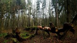
 Bory Dolnośląskie - okolice leśnictwa Śliwnik. Fot. Jerzy Wilanowski
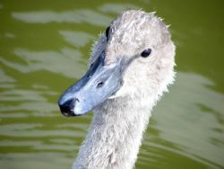 Dolina Bobru jest licznie zamieszkała przez łabędzie. Fot. Sebastian Zapolski
 Park Słowiański zajmuje większą część obszaru Doliny Bobru. Fot. Sebastian Zapolski
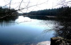 Dolina Bobru. Fot. Jerzy Wilanowski
Nature parks are areas protected due to their unique landscape, diverse ecosystems and valuable for their tourist and leisure attractions or the function of a wildlife corridor.
Szprotawa Forest District includes fragments of 5 nature parks. The nature parks are:
-
„Dolina Bobru" (Bóbr Valley) – it is a wildlife corridor of national importance with area of 13 131 ha (including 2616 ha within Szprotawa Forest District). The park includes 3 communes: Żagań, Małomice and Szprotawa. Most of its area is covered by "Park Słowiański" Landscape Nature Protected Area valued for its exceptional scenic beauty. The area is protected to preserve the landscape of Bóbr Urstromtal, the area of exceptional natural and scenic values.

-
„Wzgórza Dalkowskie" (Dalkowskie Hills) – the hills stretch out for 100 km between Żarskie Hills in the west and Ścinawska Depression in the east. The area is adjacent to Głogowska Urstromtal in the north and Szprotawska Plain and Lubińska High Plain in the south. The area is barely forested but has some sparse mixed forests including Pine and Oak, with tree stands including Beech, Oak, Pine, Ash, Spruce, Alder and Birch located mainly on hills.
-
„Dolina Brzeźnicy" (Brzeźnica Valley) – the park is located in Brzeźnica commune and covers the area of 2542 ha, including 435 ha within Szprotawa Forest District.
-
„Dolina Szprotawki" " (Szprotawka Valley) – its entire area amounts to 5570 ha, including over 608 ha within Szprotawa Forest District and includes two communes – Niegosławice and Szprotawa.
-
„Bory Dolnośląskie" (Lower Silesian Wilderness) – the park covers the area of 26 223 ha, including 238 ha within Szprotawa Forest District. The park includes two communes – Żagań and Małomice, Śliwnik Forest Range, western part of Leszno Górne Forest Range, Małomice Forest Range, southern part of Stara Kopernia Forest Range and western part of Witków Forest Range. Lower Silesian Wilderness is located between Żarskie Hills and Dalkowskie Hills in the north and Izerskie Foothills in the south. The area is adjacent to Szprotawska Plain, Lubińska High Plain, Legnicka Plain and Chojnowska Plain in the east.
Asset Publisher


![„Naplotkowała sosna, że już się zbliża wiosna.[…] A wiosna przyszło pieszo - Już kwiaty z nią się śpieszą, Już trawy przed nią rosną I szumią: „Witaj wiosno!”. Jan Brzechwa - Przyjście Wiosny](/documents/1226291/0/Wiosna+1.jpg/8e6d02a0-5ffe-d486-49c3-5fac2b3b23c1?t=1711109156614&width=42)

Asset Publisher
History
History
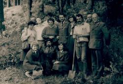 Pracownicy Nadleśnictwa podczas prac w terenie. Fot. Archiwum Nadleśnictwa Szprotawa
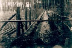 Widok na dawną szkółkę leśną. Fot. Archiwum Nadleśnictwa Szprotawa
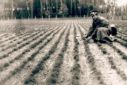 Leśnik podczas prac na szkółce. Fot. Archiwum Nadleśnictwa Szprotawa
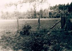 Widok na dawną szkółkę leśną. Fot. Archiwum Nadleśnictwa Szprotawa
Current area of Szprotawa Forest District was established by Director-General of the State Forests on 1st April, 1993. Earlier it had also included Żagań Sub-district (from 1976).
First chronicle notes on forest economy in the area are dated as early as 1430. According to chronicles, in 1430 the town of Szprotawa already had its own forester to manage town forests. The forests covered the area of about 4300 ha and were located in south-eastern area of the contemporary Szprotawa Sub-district. They also included the area of "Buczyna Szprotawska" that had been a protected area for a long time and in 1930s gained status of a nature reserve covering the area of 85.20 ha. The reserve in its current shape covers the area of 152.30 ha. Two commemorative stones dedicated to successive Forest Inspectors of town forests from 19th century can be still admired in the reserve.
In addition to "Buczyna Szprotawska" there were two other reserves in the District - "Wysoki Las" (Tall Forest) and "Błota nad Szprotą" (Marshes by Szprota). The District Inspectorate also protected its natural monuments – "Chrobry" Oak, at the time known as "Wielki Dąb" (Huge Oak) ("Grosse Eiche") and "Buk Trębacza" (Trumpeter's Beech) ("Trompeterbuche").
The remaining forests of the present Szprotawa Forest District were owned by rich landowners and local farmers. Even today tourists can admire border stones of Heinrich von Neuman – 19th century owner of Wiechlice estate and the neighbouring lands.
Modern history
Szprotawa Forest District was established in 1946 and covered the area of current Szprotawa Sub-district amounting to about 8000 ha. The original division was very simple – one section constituted one unit.
Between 1945 and 1951 the division was based on an approximate age class table.
From 1952 to 1965 forest management was based on the provisional plan and finally in 1965 a definitive plan based on complete appraisal was drawn up.
During all the years that have passed since the end of WWII the State Forests, including Szprotawa Forest District, have gone through a number of reorganizations and territorial divisions.
In the 1970s, as a result of enclosure of units, a single large Forest District was formed to include 4 Sub-districts (Szprotawa, Małomice, Żagań and Żuków) and cover the area of more than 100 000 ha. Currently Szprotawa Forest District includes two Sub-districts (Szprotawa and Małomice) having approximately 19 000 ha of forests each, with total territorial range of 65 000 ha. As part of the Lower Silesian Wilderness Szprotawa Sub-district forms compact whole, whereas Małomice Sub-district includes over 300 forest complexes, including 106 with area below 1 ha and 114 with area from 1 to 5 ha. Field and forest border of the Forest District is about 1000 km long, which makes it comparable with the lengths of Polish-Czech and Polish-Slovakian borders altogether.
Since 1946 Szprotawa Forest District has been managed by seven Forest Inspectors (including the current one). The most famous Forest Inspector was Zygmunt Patalas (1951 - 1952), who was later appointed the Director of Forest Research Institute in Warsaw. From 1947 to 1951 Białobrzezie Forest District Inspectorate (from 1951 known as Żuków Forest District Inspectorate, included into Szprotawa Forest District Inspectorate in 1973) was managed by Adam Szczerba, who was later appointed the Director-General of the State Forests.